Boogerman Loop Trail in Smokey’s

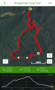
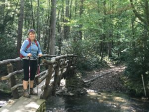 The Boogerman Loop hike is about 7.5 miles, a moderate hike that begins from the Caldwell Fork Trailhead. We initially found directions in another post with GPS coordinates, however, we were sent an hour or more out of the way. So, use our directions at the end of this posting. At the road-side parking we saw an amazing footbridge! It was clearly made by hand by the forest service – it’s sturdy, looks terrific and what a way to start our hike! Of all the footbridges we found, this turned out to be one of the longest footbridges in the Park.
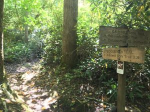 As you can see the sign says 3.8 miles on the Caldwell Fork Trail to reach the Boogerman Trail junction. We crossed the bridge and started to the junction. This part of the hike was like a walk in the park – literally, smooth, soft ground that was very well maintained. We quickly made it thru the first 8 tenths of a mile and turned left onto the Caldwell Fork Trail toward the Boogerman Trail as the sign shows. The trail starts to climb some and more and more rocks and roots appear – still, a very nice walk!
The trail receives its name from Robert Palmer, an avid nose picker, whose nickname was “Boogerman.” Legend has it that on Palmer’s first day of school the teacher asked him what he wanted to be when he grew up. Palmer replied “the Boogerman,” and the name would stick into adulthood.
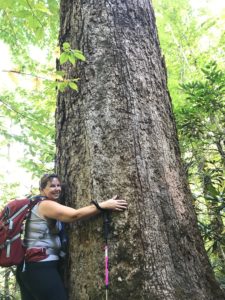 Once on the Boogerman Trail the first things you’ll notice are the trees! We have hiked Joyce Kilmer and seen old growth forests but nothing like this hike! We came across so many very large trees, including white pines, yellow-poplars, as well as
 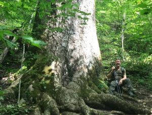 eastern hemlocks, maples and oaks. These trees are HUGE, the pictures don’t do it justice! Believe me, it was hard to see the tops. Some just went into the clouds and many were so wide that we guessed they were 50 feet in circumference!
History tells us that Robert Palmer was very protective of his forest. He rejected all buy-out offers from lumber companies to harvest the wood on his property. It’s very lucky for us to get to see trees this large. Because this forest was never poached for lumber, it holds some of the tallest trees in the Cataloochee Valley. Some have said there were remains to be seen of the former Palmer home along with a purported wagon wheel between roughly the 2.8 mile and 3.5 mile marks. We did not see the old home remnants or an old wagon wheel I’m sorry to say. As I’m not sure if they are still visible or not, please email me should you find their locations and or comment on this post and I’ll add their locations for the next hikers – we obviously missed them
 As we continued to wind through this beautiful section of our national park, it was a steady uphill drive for the first half of the hike or so. We decided to stop and make lunch. We found some great downed trees to sit on and started a small fire and threw on some sausages while we snacked on some fruit and trail mix. Nothing tasted better than our hot, cooked in the woods links! We regained our energy and continued after hearing some sounds in the woods. We dismissed this as squirrels or some animal moving around and kept on going.
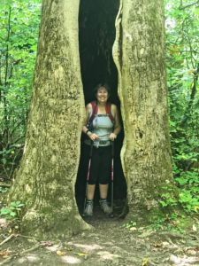
As we crested the peak and turned downhill we both felt great as a slow decent is just what we needed after a nice lunch! Then, out of the maze of big trees we came upon another super large tree which had about a 16 foot opening in it. It looked like a tiny house, a tree house i’d seen in a kids story maybe, or a bear or would big-foot walk out! As we approached Pam ran right in, I imagined I could install a door and a window and it would be a great shelter – what a great picture!
 Now on the downhill, we looked at our GPS and thought we should have seen the house, we considered that we may have missed a turn and contemplated turning around, however, we agreed to continue as neither of us saw any other trail and this one is very well defined.
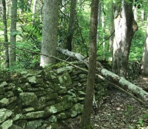
Finally, we came to some very impressive rock walls, the first was probably 80 feet in length, and 4 feet tall, and more than 2 feet deep. All in all we found 4 of these stone walls and later found they are remains from the old Carson Messer homestead. When you see these it’s really hard to believe they had the time to complete them.
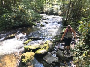 Just after all the walls the trail starts to follow a small creek known as the Snake Branch Creek, which we started crossing over several times either by bridge or hoping from stone to stone! We kept going (lucky we wore our waterproof boots) crossing over the creek back and forth many times.
After all the rock walls we came to the Caldwell Fork Trail once again and reading the sign, we turned right at this junction to continue on the loop hike back to the Boogerman connector. Upon checking our GPS we realized we still had quite a way to go. In as much as we had already crossed a bunch of creeks we found that as the trail follows the Cataloochee Creek we’d cross Caldwell Fork at least a dozen times more! It started to seem as if the crossings were getting more difficult as we progressed, each one a tad more challenging than the prior. On one crossingthere was no bridge or rocks or even sharp pointed rock edges to cross with so, we did actually have to walk across in the rushing water. With water knee high It was a tense situation, a little scarry, but we made it!
Moving on the trail and more crossings, the trail seems to disappear at one point. We followed the rocky creek bed very carefully for a short stretch and picked-up the trail again on the left side of the creek – challenging and fun was what we called the second half of this hike!
At roughly 8.3 miles you’ll finally reach the first junction with the Boogerman Trail once again. The parking area is only 8 tenths of a mile away from this point.
Because there can be so many wet crossings, some over your boot line, we suggest you bring some water shoes and fresh socks with you! We actually drove home with wet feet, socks, and shoes!
Overall this was a wonderful hike I highly recommend! You’ll see some very old tree growth, rushing streams, and maybe even some bear! (A couple we met has seen a mother and her cub)
Directions:
The departure point is in the Cataloochee section (the North Carolina side) of GSNP. Head towards Waynesville on US-23 N/US-76 E exit 102B, takes a left toward Maggey Valley, then a right on State road NC-276 to Cove Creek Road, then take the twisty SR-32 south approximately 10 – 12 miles to the Cataloochee Campground. The road will fork and you will want to bear left. Navigate your way to the Caldwell Fork Trail, you can follow the signs.
For those who like the GPS coordinates I have included them, however, they dropped us 1.5 hours out of the way!
3182-3898 Cataloochee Entrance Rd, Waynesville, NC 28785