Confluence of Sassafras and Snowbird Creek Camping & Fishing

 First I have to say, finding Snowbird is like finding a four leaf clover! We felt very lucky when we found it. This wilderness area is very secluded and not known to hikers, so the chances of finding solitude are great. We only saw two dog runners and a car camping guy with a dog. I found the name because it is a proposed wilderness area and wilderness designation has been blocked by senator Helms several times – I’m not sure what that means, but that was how I stumbled onto this hike. The Big Snowbird Trail begins at the end of Forest Road 75. Where there are 4 or 5 car camping sites that do not require reservations and were empty on the busy weekend we went – this alone would be a great time!
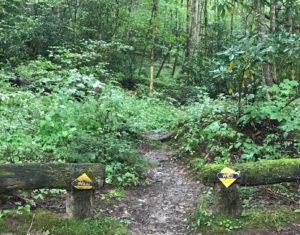
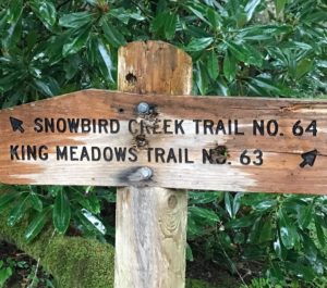
Big Snowbird Trail 64 is the trail at the end of the turn around at the end of Forest Road 75. Right way you’ll notice a trail on the left (64) for wild trout waters and a trail on the right (63) for hatchery supported waters via King Meadows Trail. We wanted to go into the wilderness and camp as well as fish so we headed out on Big Snowbird trail 64.
At times the trail resembles an old road, actually it’s an old railroad. You may see some railroad artifacts like ties and we saw an old shot-up station wagon from years gone by. The trail begins a gentle climb along Snowbird Creek. Dense rhododendron, as well as rich vegetation, beech, pine, oak among other trees separate the trail from the creek. It felt like a rain-forest – cool and moist! At times the trail is high above the creek but it never comes within easy reach of the rushing wat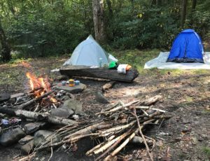 er. After 1.5 miles the trail passes a small waterfall on the left, an excellent place to splash some cool water on your face. As the trail follows the creek many small cascades can be seen on your right. At approximately 3 miles the trail comes to a camp site with the shot-up car I spoke about. Just ahead a few feet you could cross Sassafras Creek or (we found after we crossed) if you just go left about 250 feet you can cross high and dry on a nice foot bridge.
We passed this site over for the next and it was an excellent campsite just above the confluence of the Sassafras and Snowbird Creeks. We proceeded to setup camp! Boy, are we glad we did – this was an amazing location with two awesome creeks coming together! The rushing waters, the cool air, constant breeze, and easy access to either stream was really a nice treat.
We threw a line for a few moments and decided to get the steaks cooking (yes, we brought the beef) and drink the cold beer the frozen steaks provided! This was a great feeling after the 3 mile hike in with fairly full packs.
 The next morning we woke at dawn and had a terrific breakfast with this amazing backdrop and head clearing sounds of rushing waters and cheerful birds singing.
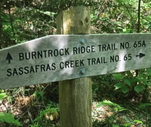
Due to a hurricane in Florida and the worries that go along with that (family, friends, properties, etc.) we decided to do a quick hike up to the ridge to see if we could get cell service to contact our wives. Of course, we’ve all learned since boy scouts to always be prepared and for some unknown reason we both head up the mountain without water, food, or even a jacket! It turned out this would take us up another 3 miles. The good news is that we made it to the top and did get both Verizon and AT&T service to phone home and look at the news for a moment – all was well at home and in Florida, so we headed down and saw signs for Burntrock and Sassafras trail 65A and 65 respectively. Along the way we heard and visited some amazing waterfalls that were worth the trip and returned to our camp, hydrated and jumped right in fishing! We both had several bites and Scott actually caught a small brown. As great as this spot was we didn’t spend enough time on the water and decided we’d come back and stay here again or possibly go in another mile or two for the legendary big browns!
For the next visit:
Another 1.5 miles down the trail there are a couple of good side trails that lead through the thick rhododendron to the multi tiered falls on the right. in another 1/2 mile you’ll cross the creek on a sturdy log bridge. On the other side is an excellent open area for camping. There is plenty of room for many groups to camp and a trail junction. There are many “fishing trails” here and it’s easy to take a wrong turn. This is also the junction of 64A, a dry route that takes you to the other side of Middle Falls. 64A climbs a hill steeply and rises above and out of site of the creek rapidly. After a mile the trail passes a junction on the left with Middle Falls Overlook Trail. This is a spur that has a nice view of the falls. Just ahead the trail rejoins Trail 64 at a cable bridge which is at the Junction of Trail 64 and 64A.
Taking the “high” trail (64A) is ideal for cold weather hiking. If you feel like splashing around, take 64 instead. In a mile it crosses the creek 11 times! After reaching the cable bridge, turn right on the trail without crossing the bridge. This will put you back on trail 64. At the bridge there are several good campsites right beside Snowbird Creek. This is probably the best camping area! Middle Falls are very beautiful and there are plenty of beautiful creekside sites here. Less experienced backpackers and hikers should make this a “turn-around” point or spend the night. After this, trail 64 becomes more and more difficult to follow because so few ever take it anymore.
When we return:
You’ll continue hiking through dense Rhododendron on big Snowbird Trail (64) you’ll rock hop several branches. Upper Falls, approximately 1.5 miles past Middle Falls, are difficult to access because of thick Rhododendron. It is, however, possible to view them from the trail. Another mile down the trail, after you cross an un-named branch, is a large cache of railroad artifacts. In the clearing you will see several large metal parts. If you bush whack up the branch to the right of the main trail you will see more metal parts, some paint cans and a possible railroad junction. A very interesting place to explore or to make camp. As with most of this section of trail, the foliage is so thick that very little light reaches the forest floor.
After this clearing the Big Snowbird Trail is very hard to follow. Here it begins its’ many crossings of this pristine creek. There aren’t any alternate trails to keep your feet dry so in cold weather or times of high water you may want to back track to the trailhead. From here to the you will notice thick grass and Rhododendron along the trail. Brook trout are residents of this creek, proving that this water is very “clean”. Because of the erosion caused by careless logging practices, the creeks in this area supported no fish population for many years. Thankfully the creek has completely recovered and now supports a healthy fish population including the “Brookies that jump on your hook”!
For the VERY daring:
First of all you should have left another vehicle on the Skyway… directions to follow.
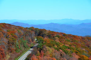
 At 8.5 miles the trail junctions with the Mitchell Lick Trail. This is a welcome sight after thrashing through the rhododendron! The Mitchell Lick Trail (#154) leads up (1.5 miles) past the King Meadows Trail (63). To continue to the Skyway, and your other vehicle, continue your climb to the junction with the Hooper Bald Trail. At this junction, a left will take you .1 mile to the parking area on the Cherohala Skyway. A right will take you to Hooper Bald in just one fifth of a mile. The Cherohala Skyway was a very controversial issue during its planning and construction. The local residents needed a highway to connect with Tellico Plains for hunting, tourism and other purposes.
Directions:
Drive to FOREST ROAD 75 in Robbinsville. To reach the trail head, take Route 143 west out of Robbinsville, NC. After passing views of Santeetlah Lake on the right you will see Snowbird Rd (S.R.1127) intersecting with Rt. 143 on the left. Turn here and continue for approximately 2 miles or 3/10 mile past Robbinsons Grocery. Turn left on Little Snowbird Rd. Continue on Little Snowbird Road for approximately two miles. Look for Big Snowbird Rd-(State Road 1120) a dirt road on the right this is FR 75. Turn right here and follow it until the end. This is the trail head. The Snowbird trail is straight ahead and over a large berm.
 In the event you’ll need to drop a second car at Big Junction, following the original directions continue on 143 out of Robbinsville, past Snowbird Road and continue on until Route 143 becomes the Cherohala Skyway. (the way Scott and I did when we first missed the hairpin turn) After a spectacular drive to the higher elevations, enter the Hooper Bald rest area on the left. It is a developed rest area that is past the 5000 elevation sign and on the left. The graveled Trail head begins at the picnic tables. Follow the trail signs to enter the Snowbird Basin. Drop one of the vehicles off here and double back to FR 75. Overnight parking is allowed at both locations!