Cove Creek Falls – Left & Right

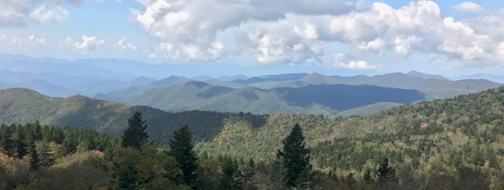
The National park hikes are some of the best in North Carolina. The scenery on this loop hike are spectacular! Along the way we’ll see amazing views on the Blue Ridge and see several awesome waterfalls, and untouched natural woods on our hike! Overall, I’d call it moderate to easy for the wide “road” like trails although there are a few steep climbs and some rough spots. Pam and I enjoyed the 6 miles in the wild!
We started by taking the road leading uphill along the creek. After some research we found the best most direct way to Cove Creek Falls – following the creek from the parking area straight up! There are a few other ways to get there however, this is the easiest and most direct.
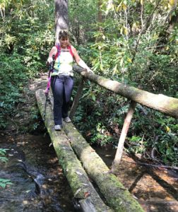
Go up the gravel road behind the gate (there is a large sign board on the right you might want to read). In about 500 feet we came to a creek crossing… After contemplating carrying Pam over because she didn’t have her waterproof shoe’s, we eventually found that there was no need to get wet, we found a side trail to the right leading to a footbridge to the other side. We continued up the road
with the creek on our right and passed several small cascades with potholes in the rock – looked like a great place to dunk your feet on a hot day. As we came up the gravel road we came upon a large open area that had picnic tables, large fire pit, and bathrooms.
We noticed the Caney Bottom trail and sign going uphill on our left, just before the big clearing. Don’t take this trail just yet, go straight through the large clearing. We made a pit stop… and noticed the road entered the woods just past the bathroom on the other side of the clearing. Be sure to look right, there is a small “sliding rock” with a large pool at the bottom – we imagined bringing kids here to slide down the natural slide one summer!
The road came to another creek crossing again, but we were wise to the “secret” path left very close to the creek leading to another footbridge and ultimately connecting back to the road again before entering clearing complete with a second bathroom, fire-pit, picnic tables and grills! The gravel road ends in the clearing, take the trail to the left at the far end of the clearing leading upstream along the creek.
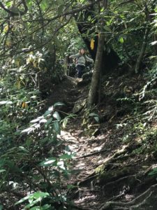
Just ahead, the blue-blazed Caney Bottom trail joins from the right in two different places. It follows the creekside path upstream for a few feet, and then exits to the left to cross the creek on a footbridge. Just keep on going straight, up the right side of the creek. The trail is easy to follow path on an old roadbed. The path is very easy at first, but soon starts climbing. It goes up and down some just before reaching the falls, about 850 feet past the Caney Bottom bridge. After following this path
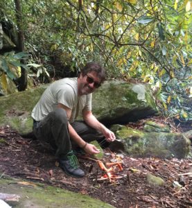
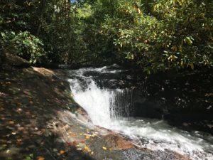
upstream we finally made it to Cove Creek Falls. It was a terrific view, and a perfect place to relax, start a fire and cook our lunch! Knowing Pam didn’t have her waterproof boots, we gathered some flat rocks and positioned them for easy creek crossing after lunch.
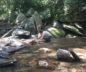
As I placed the rocks and crossed the creek I found the view from the right side of the creek much better than on the left side where I have read is where most people wind up. In fact on this first half of the hike we didn’t see a soul.
(There is also a muddy, steeper, eroded path on the other side of the creek leading up to the falls that has a worst view. So, don’t bother taking it – stay on the right side of the creek!)
After a great lunch and desert we decided to cross the creek and start the other half of the hike. It was a tad tricky crossing but we used the well placed rocks and our poles to balance and made it to the other side without issue. Still, be careful because there definitely is dangerous drop from the pool over the logs.
After you get across, take the trail straight ahead, which leads around some big rocks and climbs to a trail intersection going left and right – turn
right.
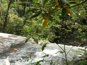
This trail leads to a point near the top of the falls and it looks a tad steep, it’s short and not hard at all. As the path leads up be sure to take a few side trails right to see the falls at different levels of drop. At the very top it’s uncanny how the water leading to the falls is very slow and just a few feet later it’s roaring over the top – see that picture, really amazing! Back to the trail going up you’ll soon see it forks left or right, while you can take your pick we took the one on the right. In another 200 feet or so we came upon another trail junction which we later found was the yellow-blazed Cove Creek trail, turn right at this junction.
The Cove Creek trail is wider, on an old logging road, and easy to follow as I mentioned we ultimately saw the yellow blazes. It’s very gradual and a welcome walk as we enjoy the breeze and the sounds of the forest and waterfall all around us. We did see a couple people hiking here and a mountain biker as we
climbed up and over roots we wondered how the bilker could stay on his bike!
Near the top of the climb, a long, nice wooden bridge crosses a dribbling part of the creek, just past the bridge, the trail climbs some steps and bears right follow the yellow blazes. it seems we switched back and forth and hiked up and down for some time. Then again we saw the biker carrying his bike across the bridge saying “some guys can ride down these rocks and across a bridge with one log…” Again, hard to imagine!
You’ll reach another log bridge, the trail will turn right, and then you’ll reach a trail intersection. The Cove Creek trail goes left and intersects gravel road FS 225B in about 1/2 mile I read that some people enter from this road. Don’t go that way the trail we took and you want is straight ahead, and it’s the Caney Bottom trail (blue blaze). This marks the highest point on the hike – it’s all downhill from here!
The Caney Bottom trail, as you head downstream, drops over a small series of falls and cascades to your left. It’s hard to get close view of this first set of falls and they are not the best anyway, soon the creek levels out, and the trail descends to catch up with it before the water drops over a larger, more significant falls. This one is easily visible from the trail but almost impossible to get to the base of. Just beyond the falls, the trail travels through an open section of woods with the ground carpeted in ferns. The trail catches up with the creek one final time, before it drops into another set of cascades. This last series of falls is smaller than the one above, and it lies between huge boulders as it becomes a rain-forest of sorts..
This third set of cascades is the last on our hike, and the trail will begin a slight uphill climb as it wraps around the end of the ridge between this and Cove Creek. The trail will intersect with a couple of different trails leading out of the clearing/picnic area, we found you can bear left on either of them back to the gravel road we came in on to return to the parking area.
On the walk back to the car we met a nice couple from Idaho vacationing in Asheville searching for a place to retire – we shared some ideas for them to enjoy some small towns like Waynesville, and Bryson City as well as some great restaurant and brewery ideas.

On our drive home we decided to take a short detour to Balsam Lake, it’s a day use area that appears to be a great fishing destination, we took a stroll of the path and viewed the like from two small piers. We also noticed the Balsam Lake Lodge – The Balsam Lake Lodge offers a special getaway for groups who reserve the whole facility for $170 to $200 per night. The lodge includes 16 twin beds with linens, a kitchen with utensils and three bathrooms. All facilities are fully accessible. The lodge overlooks a lake where trails and fishing piers are fully accessible.
Directions:
GPS to National Forest 475 Rd, Brevard, NC 35.283156, -82.817331
Drive US-23 N/US-74 E towards Waynesville, enter the Blue Ridge parkway turn left toward Asheville for 20.1 miles exit at NC-215 ramp, turn right onto NC-215 S (signs for Rosman) Turn left onto Indian Creek Road go 2.1 miles, Turn left onto National Forest 475 Rd go 3.7 miles to the entrance on your left, with parking lot on your right.
Bring water, food to eat at the falls and have a great time!