Glen Falls Hike – Highlands

 We have been to Highlands numerous times! We’ve done a bunch of hikes including waterfall hikes up there. I say up there because it’s 4100 feet in elevation in town! However, this hike and the 106 west was the first time we stumbled on this. And a restaurant I’ll tell you about later. It was certainly one of the most spectacular waterfalls we’ve seen near Highlands. It’s actually Overflow Creek that plunges over the ledge below Highlands, you really get to see three falls in one as it forms two distinct tiers of falls totaling over 200′ in height, each with an entirely different look and feel. Then another very nice falls below that! For a total of 3 waterfalls and one cascade. I highly recommend this hike, it is a tad rooty, but plenty of stairs make it an easy decent and a slightly harder assent.
Directions: Starting in Sylva, head toward franklin, turn off west on US 64 (Mountain Waters Byway) once in highlands from the corner of Main Street and 106 go west 1.6 miles and turn left for the Glen Falls Scenic area, then IMMEDIATELY right onto the gravel road. Continue down this road for nearly 1 mile and park. Begin the trail behind the sign board. A trail leading up Chinquapin Mountain immediately turns right (3.5mi.). Stay left on the Glen Falls trail. After about .1mi you’ll come to what looks like the end, on the left there is an overlook where you can see the Blue Valley, and the foothills and beyond to the South Carolina Piedmont region in the winter months. On the right you’ll see a trail start downhill. You’ll find lots of galax on the ground and plenty of rhododendron and mountain laurel along the way. On its way down, the trail has many steps built in to ease your descent, but with lots of roots, a wet spot or two, and some erosion, the trail is moderately rough. You’ll reach a switchback near some cascades above the falls. A side path leads to a small overlook with railing to keep onlookers out of the creek and off the slick rocks. The trail pulls away from the creek and you’ll reach a split. Turn right to reach the creek again, and another railed overlook at the brink of the main upper falls. You get a spectacular view of the water spilling over the sheer rock cliff. The side path is a bit rougher than the main trail but very short.
Return to the split, and go straight. The trail travels away from the creek for a short while, around the nose of the ridge, letting you get a through-the-woods view of the next cove East. The trail switches back again to the right, then heads back toward the creek before coming out at the bottom of the upper falls.
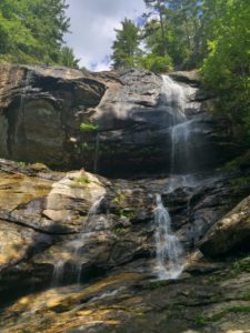 The water comes down in two distinct falls; the right side generally has more water. Be careful if you decide to venture very near the falls – the bank is steep and slippery, and the rocks are slippery as well. There is a large flat area just below the second fall and this is where we had lunch.
The middle section of Glen Falls is more of a spreading cascade than the top, with multiple tiers, ledges, and pools.
The trail makes a left at the falls, which marks the tip of another switchback, and continues down the ridge. You’ll wind through another set of short switchbacks before coming out at the base of the lower falls.
You’re closer to the creek than at the upper overlook, but the rocks still aren’t level. The creek does continue over another, small falls, so be careful here as well if you go out on any rocks. A perfectly safe viewing area is located on the trail at the edge of the creek, so enjoy the view from there.
Keep going and you’ll see three falls and a beautiful cascade – really a great hike!
Return to your vehicle on the same path. If you have time do the Chinquapin Mountain trail for another 3.5mi. hike. Remember: it’s up the stairs going back, so it might take a little extra time.
***Bring lots of water, sunscreen, and lunch as we will eat on location! BYOB optional.