Panthertown 8 Waterfall Hike

We will do 7 waterfalls and be home for dinner! Starting with Raven Rock, then Shower Falls, Mac’s, Pothole, Schoolhouse, Par and Glove falls in no order – you’ll have to discover them!
Start with Raven Rock Falls:
To get to Raven Rock Falls take 281 north from Hwy 64 a mile or so then veer off to left onto Cold Mountain Road. A fire station will be on your right (looks like they have a large budget up here). Cold Mountain Road winds past Lake Toxaway. Just past most of the homes, the road used to be gravel as it climbed up the mountain, but it was paved a few years ago. 3.9 miles up the Cold Mountain Rd on the right you will see a small waterfall called Shower Falls. It was a trickle for us and really on the road, we will count that as number 1 as it added to our excitement. Notice the telephone poles on the way up for small numbers on a few and just count them up to pole #61 then part just past on the left – 4.5 miles from 281 – you can park and follow a trail down to Raven Rock Falls. The trailhead is past the pole and it’s well worth the 1-mile hike, we had a snack and relaxed listening to distant waterfall sounds along with the Raven Rock sounds. This was a great stop and our number 2!
Keep going up Cold Mountain and at 5.7 miles total you’ll see Canaan Land – a religious retreat – on the right. The road straight ahead is now gated and private (the old entrance), but you take a left and head up the gravel road a very short distance. The entrance to Panthertown is on the right after the turn off of Cold Mountain Rd and there is a parking area. You’ll see a sign right past the turn into the parking area saying that straight ahead is private Lake Toxaway Estates property. Just as you turn right, notice a trail on the left that will take you towards Greenland Creek Falls. We did this one next and was our #3. Then after we returned to the car we drive to the end where we saw the other trailheads. There is a kiosk with a copy of the new forest service trail map. Land to the right side of the lot is private Canaan Land property and is posted. We ran into a group of kids all dressed similar with very, very baggy shorts that could be shirts or shorts so it was hard to tell the sexes of the kids, about 20 of them with one teenager and no adults – can you say cult?
Parking for the rest of our hike is also at the Cold Mountain (east) entrance to Panthertown Valley. Our hike is a more adventurous way to reach Schoolhouse Falls and you’ll get to see 4 smaller waterfalls also! Two of the waterfalls are Mac’s Falls and Pothole Falls – the other 2 are not on the maps you’ll only find them here (Par and Glove Falls). Most people only know about the Schoolhouse Falls trail, we did an awesome loop back up to the parking area via the Panthertown Valley Trail for a total hike of about 3.5 miles. Part of the trail is not on the official forest service map which is what made it more exciting if you ask me!
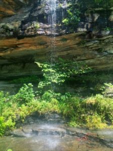
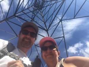
Take the Greenland Creek Trail #488 on the left side of the kiosk. Our goal is to come back out on the Panthertown Valley Trail which is just to the right of the kiosk. Follow the Greenland Creek Trail a very short distance to the power lines and walk under the tower. The trail continues on the opposite side into the woods. After about 10 minutes from the trailhead, the trail splits and is not marked. The Greenland Creek Trail bears to the left, but you’ll want to head right and down to the sound of Mac’s Falls number 4. In another couple of minutes, the trail splits again. Take the left trail to head down to the waterfall. You’ll be at the side of the waterfall – to get a frontal view you’ll either have to wade out into the creek or head down creek about 20-30 yards and look for the small island you can hop out onto. The waterfall isn’t very big – maybe 10′ high – but it’s nice and secluded.
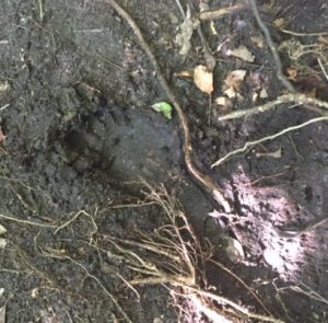
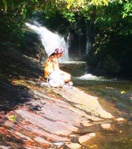
From here, retrace your steps back up to the split and head left and down the creek towards Pothole Falls number 5. It’s not very far, you’ll descend over a tangle of rhododendron and mountain laurel roots, then come to another split. Go right and come to a small section of exposed rock you’ll have to maneuver around. It may be slippery, there’s a lot to hang on to. Continue down the trail a very short distance to Pothole Falls. The trail empties out on the bedrock below the waterfall (at the point where Pam is sitting to the left), but getting from trail to bedrock is tricky as you’ll see. It’s a little steep, but only for a very short distance. Hold on to the last shrubs and stay low in case you slip. This area is fairly open and there are several potholes near the waterfall. It’s a great area to hang out. I actually extended my hiking pole as long as it would go and it never hit the bottom! This is where bigfoot drinks… We actually took this shot, the barefoot imprint was 12″ wide – never saw a foot that big!
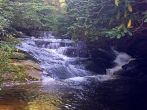
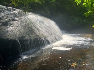
The trail picks up a short distance down the creek and you may have to get a foot wet here. Stay tight to the rock on the right side of the creek. As soon as you are around, you’ll see the trail on the right. After a very short distance down the trail, you’ll see a wet weather trickle falls through the shrub on the right. Continue down the trail and through a small ravine. In less than 10 minutes from Pothole Falls, you’ll come to Glove Falls number 6. There’s an area just down creek where you can get out for a better view. This is not the largest waterfall, but the pool area below makes for a great scene in good light. Enjoy the sound and view!
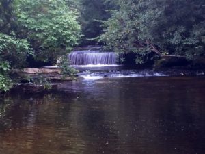
Continue down the trail from here and in a few minutes come to a more open area where I may return to camp and fish! Easily space for 2 tents. In a few minutes, we came to another split, we went left and it was cool, a dangerous view – stay to the right and down through the laurel tunnel. The next waterfall, Par Falls coming right up number 7. This one is really nice also and has much different character than the last.
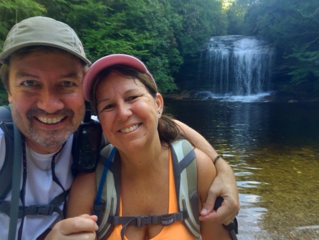
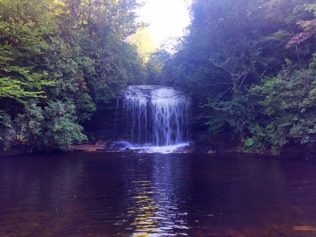
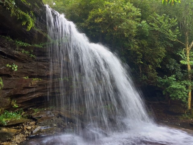
After leaving Par Falls, continue down the trail and cross a small feeder creek. In another 5 minutes come to another split. Go left and down. At the next trail split, go right and in a couple of minutes you’ll be at the top of Schoolhouse Falls number 8. Again there is a small trail to the top – don’t do it! It’s really dangerous, I can’t imagine what would happen if you slipped! Take it easy, if you continue down to where a trail to the left brings you out at the base of the falls you’ll get a much better view anyway! You can get up to the side for a nice view from under the overhanging rock. Or, crossing the rocks where the creek continues down will take you to the beach area in front of the waterfall. Here are a bunch more views behind, in front, and around Schoolhouse Falls.
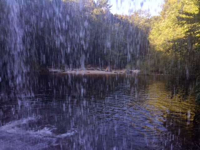
You can see Pam on the sandy beach from behind the waterfall – this was exhilarating! From the sandy beach area facing the falls look behind you to the right for a small trail going up – take it and you’ll be happy to see a rock chair formation that will seat 7 around a firepit! Perfect to warm you after a swim!
When you are ready to leave, from the beach area facing the waterfall, look to the right and you’ll see a small set of steps. Head up there to the split. Going left on the Little Green Trail will take you to some awesome views of Little Green Mountain. To continue the loop back to the parking area, go right at the split, over the boardwalk, and a short distance to the Panthertown Valley Trail. Turn right, go over the bridge, and continue up the trail which is now a gravel road. Pass the Devil’s Elbow Trail on the left and continue on straight. In 3-4 minutes you’ll come to a flat area where you should see a trail to the left. You can take this up to the left and up at a split and come out higher up on the Panthertown Valley Trail past a few switchbacks. Or you can just continue up the main trail. Either way, you’ll cross under the power lines again before reaching the gate at Caanan Land. Turn right and follow the trail over the creek and back to the parking area.
If you need a GPS file download here.