SAM’s Knob Loop w/Lunch option & Buck Springs Lodge Trail

We began the hike heading out on the trail next to the restrooms. We knew to look for the Blue Blaze markers for the Sam’s Knob trail and an orange blaze for the Flat Laurel Creek trail, w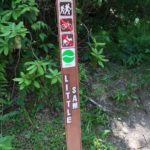 e saw no other blazes along the path other than a yellow taking off to Little Sam – one day we may come back for this one! I read this from Bob Smith “The views from the cliff just below the summit of Little Sam Knob offer the best views I have ever seen of its larger namesake, Sam Knob. So I highly recommend the bushwhack to the top, regardless of the route one takes to get there.” So, if you ever want to do it you can start here!
We saw some spur trails taking off left and right to camping spots and followed the trail around the hillside, we had a very dry 69 degrees so navigating around wet muddy areas was not a problem. As we proceeded downhill the rocky, gravel ditch lead us to a staircase (well built) leading to the valley below with lots of beautiful wildflowers. We passed some more side trails going off into the grass that could me sites or views. As you come down the staircase you’ll see and excellent view of the double hump of Sam’s Knob directly in front of you!
As you reach the base of the mountain, the trail splits with the Sam’s Knob trail continuing downhill to a fork in the trail, the left takes you to well marked intersection and the right to Sam’s Knob Summit trail. For the next 400 or so feet or .65 miles you’ll be climbing pretty much uphill. When you reach the wooden stairs you’ve made it about halfway. Again there will be several side trails, the main deep ditch that you have been following will split, with each direction going to one of the two summits. Look for the large quartz boulder on the way to the north summit. Both offer great 3600 views of the ![347688[1]](https://www.busyhiker.com/wp-content/uploads/2016/06/3476881-300x97.jpg) surrounding mountains we saw Little Sam from here and the “line” of where the new trees were planted – you can see that in the picture and it’s amazing in person! Whichever way you go has to be good! We took the left to the north summit and it was breathtaking!
surrounding mountains we saw Little Sam from here and the “line” of where the new trees were planted – you can see that in the picture and it’s amazing in person! Whichever way you go has to be good! We took the left to the north summit and it was breathtaking!
To continue the loop just retrace your steps back down the mountain, continuing along the Sam’s Knob trail back the way you came – just before you get to the very bottom where you split right you’ll see a right to the Flat Laurel Creek trail – take this small short-cut! As you proceed on the FLC trail you’ll notice muddy and wet patches I bet after a big rain it would be very wet because we came upon well made wooden platforms to help get thru the water and or mud. Following down we first after a stream crossing we saw a very nice camp site or two on the left and some shady areas along Flat Laurel Creek where you could camp. I’m sure in the spring rushing water would sound awesome to sleep nearby.
After a second crossing over a great swimming hole we found the junction with the Flat Laurel Creek trail. Turn left her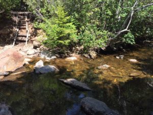 e to hike back up to the parking lot. Some of this trail was a tad wet as well, with lots of rocks to sprain your ankles on and several more small water crossings. Several side trails take you back to the creek and offer excellent places to hang your hammock. For the last mile, the trail opens up to some very nice views of the area you just came from. We ignored more side trails and stayed on the wide main path which will connected back to the parking lot where we found our jeep just as we left it!
It’s 3.9 miles total for the loop and then if you are hungry you could go for lunch at the Pisgah Inn. We thought we’d possibly take another hike after lunch on Bucks Springs Trail but since we had a late start we headed home. Just so you know, the Pisgah Inn opens at 11:30am (they don’t take reservations).
For the second option after lunch head over to the far side of the Pisgah Inn Parking Lot and take the Buck Springs Lodge trail. It’s 2.2 miles round-trip. You can see that hike here.
Starting point: Black Balsam Parking Area
Take Blue Ridge Pkwy to Black Balsam Knob Rd in East Fork
Enter from US-23 N/US-74 E in .5 mi
Turn left onto Blue Ridge Pkwy follow for 23.3 mi
Turn left onto Black Balsam Knob Rd – Destination will be on the left