Turkey Pen road into Pisgah National Forest

Once you’ve parked, make sure you set your GPS if you have one and begin! The trail starts downward and Rooty, shady and fairly easy. Soon you’ll hear water to your left and you’ll come up on S. Mills river, look for 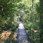 the first footbridge to cross it and bear left at the next intersection and white blaze. Following the 133 trail is very nice, we saw several camp sites that could accommodate larger groups and also some attractive fishing holes! We kept on,
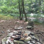
along the way we saw the remains of Cantrell 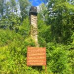 Lodge, the early day (1890’s) Biltmore Forest rangers stayed there as did thousands of guests – you can just imagine what it must have been like back then.
continue along south mills river, you’ll be crossing 2 more times over suspended foot bridges the 3rd one gave loose to one unlucky hiker before us! 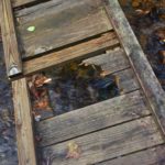
Anyway, after about 4.5 miles we decided on a site at the crux of the S. Mills river and Cantrell Creek. We liked the sound of the rushing water as well as the clear open area to view the stars. We found some almost level ground to pitch our tents and settled in.
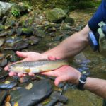 Once setup we went up stream fishing and caught two very small Rainbows fairly quickly. Then Brian caught a 14″ brown that we were definetly keeping for dinner! Needless to say we ate very well! Pasta Primavera and Chicken Dumplings, we even had desert – creme brûlée!
Talked into the night and enjoyed the stars, company, and bourbon before hitting the tents.
Up at dawn we got ready to fish, had coffee, breakfast, used the “facilities”, packed lunch and off we went with the understanding that we needed two 12″ or larger trout for dinner!
We had an amazing time fishing all day and managed to store two nice sized Brown Trout on the creek to keep chilled.
Brian was kind enough to show me some new technical tricks for long range casts involving double loading the line – I was very happy to learn!
 Ultimately at about 4:pm we found a very cool camp site another 4 miles or so up from ours with a single rock chair. It was after 2 or 3 more stream crossings on the opposing side of Cantrell Creek. I took a break and Brian went onward for “one last cast”, what a great day!
After some time relaxing, I tied a new fly and hit the water in the calm hole just below the site, got a few bites and pulled another baby out – pulled the hook with my forceps while I considered for a moment biting into some cool fresh brown trout sushi! I threw her back into the hole…
Then Brian comes clashing threw the water calling my name! I said over here, he likely thought I was still in the rock chair, he said BEES! I immediately took off away from him as fast as I could saying where’s the white trail back while staying in the lead all the while knowing the bees could be following him.
Then out of nowhere one circles me and another – BANG, nailed me in the back of my upper arm! I speed up, almost running, down stream again asking where’s the trail.
 To make a great story shorter, we made it back alright, relaxed around camp, had another excellent day!
Directions to trailhead: Head toward Waynesville from Silva, past Clyde, take 40 toward Asheville exit toward the AVL Airpart on 280, go past the airport for 12 miles. Male right on Turkey Pen road, continue up past the National forest sign then park at the trail head board in Pisgah National Park. Start to the left of the sign on the white blazed trail number 133. Stay on the trail for 4.5 miles total.
***For camping bring water a filter to lighten your load!